I myself feel that I have contributed what I have to contribute to understanding Douglass and the world that he lived in, at least for now, and am working on two other projects. They actually do relate to him, but more on a macro level of race, gender, and narratives of U.S. history. Some of it requires watching a lot of 1970s t.v., a task for which I have trained my whole life. Then, there is the whole teaching thing that includes experimental methods with world civilizations this semester. (And, holy cow, but teaching a room full of 19-year-olds about an event that happened when you yourself were 19 and teaching about it as history is surreal!)
But, this is all beside the point of this post. This morning, on Facebook, someone shared this article, "It looks like a video game, but it's not. It's a 3D map of the buildings, roads and land in 1815 Baltimore, created by UMBC," from the Baltimore Sun. Oh, my god! What fun!
The article links to the digital history site Visualizing Early Baltimore, where they have used old maps, and current maps, and all sorts of digital wizardry to recreate 1815 Baltimore in 3-D -- a bit like in Assassins Creed (or what I know of it from watching my nephew play it), but not quite so far as to have an avatar in which to walk around in the city. Now there's a project!
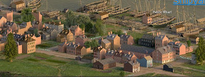
Here is a view of the city from the project.:
Here is Philpot Street, where he lived for a while as a teen and from where he described hearing Austin Woolfolk march slave coffles to the wharves at the foot of the street to be transported off to New Orleans.:
The Strawberry Alley AME Church, where he sometimes went, and where Anna Murray probably went, and where the men in the East Baltimore Mental Improvement Society went.:
Speaking of Anna Murray, she worked and lived along Caroline Street, which is the long street cutting diagonally through this image. Her employers were around the intersection of Gough, which is visible there about halfway up from the bottom.:
You can get an idea of how very closely everyone lived and how that would impinge upon the lives of African Americans, who would be under close surveillance. At the same time, the black population was probably far more aware of the activities of the white population than the other way around. I wonder what might be revealed by putting together a project like this with a runaway slave ad project or like the work that Christopher Phillips did in mapping black residences in Baltimore.
Then, of course, I think of my nephew saying, "kids will only get into this if you make it into a game."


